
Higher Roads, Same Floods? Why Raising Roads Alone May Not Solve Flooding in the Philippines
Have you ever noticed a road that has been raised to reduce flooding, only to see water accumulate in nearby streets or residential areas? While elevating roads can help keep important routes accessible during floods, it does not automatically eliminate the water causing the problem.
Introduction
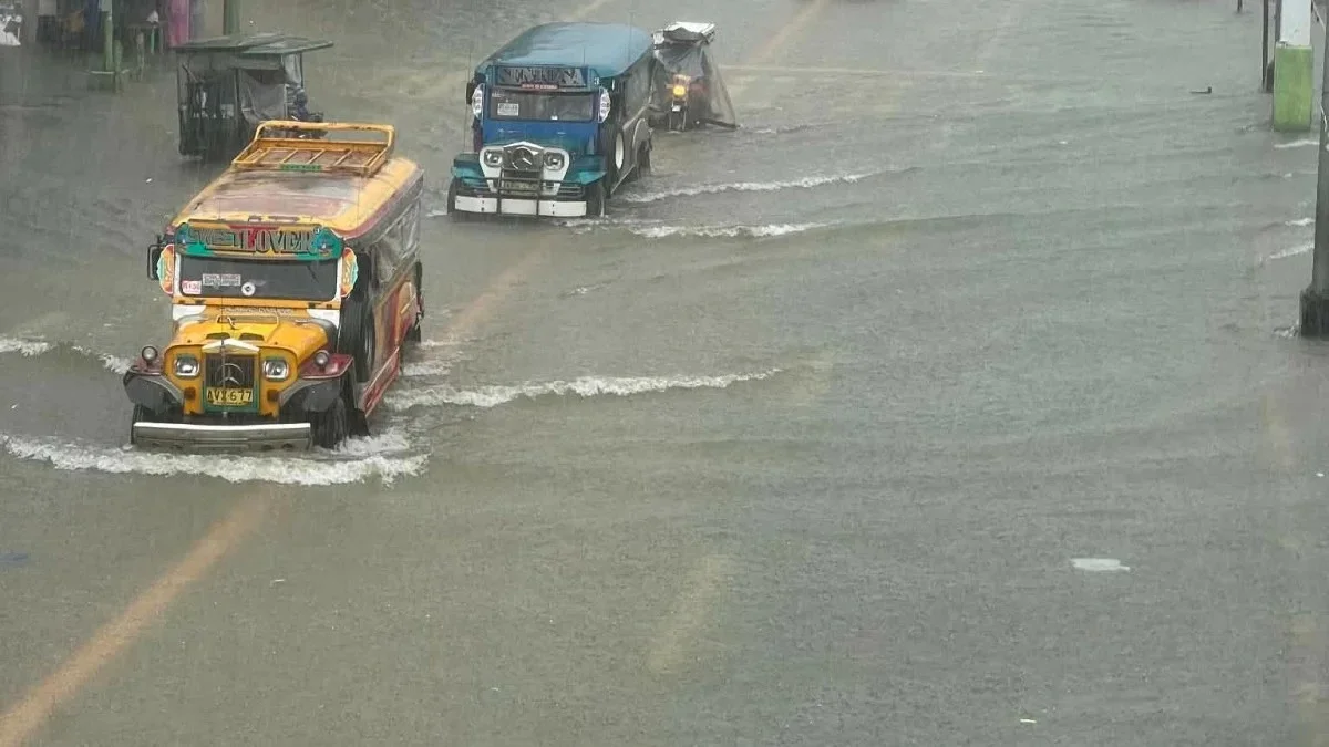
Have you ever noticed a road that has been raised to reduce flooding, only to see water accumulate in nearby streets or residential areas? While elevating roads can help keep important routes accessible during floods, it does not automatically eliminate the water causing the problem. In some circumstances, raising a road without considering drainage and the surrounding terrain can even redirect water toward lower-lying areas.
This issue has become particularly relevant in the Philippines, where many communities experience recurring floods during periods of heavy rainfall. In Dagupan City, Pangasinan, the Department of Public Works and Highways (DPWH) has been pursuing an integrated approach that combines road elevation with drainage improvements, pumping, and water-storage facilities. In a report published on September 18, 2026, the Philippine Information Agency highlighted the importance of providing adequate pathways for floodwater rather than treating road elevation as a stand-alone solution (Philippine Information Agency, 2026).
The situation raises an important question for civil engineers and urban planners: If roads are designed to stay above floodwater, where will the water go?
Why Are Roads Being Raised?
Road elevation is an engineering intervention used to raise the roadway surface above a specified flood level. It can help maintain access to essential facilities, reduce interruptions to transportation, and protect the pavement from repeated inundation.
In flood-prone areas, roads that sit too low may become impassable during heavy rainfall or high water levels. Raising selected road sections can improve their usability, particularly along important transportation routes used by emergency services, public transportation, and local communities.
However, road elevation primarily addresses the vulnerability of the roadway itself. It does not necessarily reduce the total volume of floodwater in the surrounding area.
The Federal Emergency Management Agency (FEMA) explains that raising roads can help keep them operational during floods, but the approach requires careful consideration of surrounding flood conditions. In some circumstances, an elevated road embankment can act like a dam, obstructing water movement and increasing flood levels on one side. Possible design responses include providing culverts or elevating the roadway on piles, depending on site conditions and engineering requirements (FEMA, 2022).
This distinction is important: protecting a road from flooding and protecting an entire community from flooding are related, but they are not the same engineering objective.
The Hidden Problem: Where Does the Water Go?
Floodwater follows gravity and responds to the terrain, drainage network, river levels, and other hydraulic conditions. When a road is raised, the resulting changes in elevation may affect how surface water moves across the surrounding area.
Consider a residential neighborhood where the road is lower than the surrounding flood level. Raising the road may improve access along that route. However, if nearby properties become relatively lower than the new road surface and no adequate drainage outlet is available, rainwater may accumulate in those properties.
This does not mean that road elevation always worsens flooding. The outcome depends on the existing topography, drainage capacity, flood levels, and the way the project is designed. The engineering concern is whether the intervention improves conditions for the wider drainage area or simply transfers the problem elsewhere.
The DPWH highlighted this concern in Dagupan City, where officials emphasized that road elevation must be accompanied by adequate drainage and other flood-management measures. The objective is to improve water movement while reducing the risk of shifting floodwater toward lower-lying communities (Philippine Information Agency, 2026).
For civil engineers, this illustrates why flood mitigation should be evaluated at the catchment or drainage-system level, rather than solely by examining the elevation of an individual road.
The Engineering Principles Behind the Problem
1. Hydrology: Understanding How Much Water Must Be Managed
Hydrology examines rainfall, runoff, infiltration, and the movement of water through a drainage area. Before designing a road-raising project, engineers need to understand how rainfall becomes surface runoff and how much water the surrounding area may generate.
Important considerations include rainfall intensity and duration, the size of the contributing catchment, land use, soil infiltration, and the condition of existing drainage systems.
For example, when a large portion of a neighborhood consists of roofs, concrete roads, and paved surfaces, less rainfall may infiltrate into the ground. More water can therefore become surface runoff, increasing the amount that drainage facilities must manage.
Raising the road without evaluating these conditions may protect the pavement but leave the underlying drainage problem unresolved.
2. Hydraulics: Ensuring Water Has a Path to Flow
Hydraulics focuses on how water moves through drainage channels, pipes, culverts, rivers, and other conveyance systems.
A drainage network must have sufficient capacity to carry runoff toward an appropriate outlet. Even a well-designed road elevation project may provide limited flood relief if drainage inlets are blocked, pipes are undersized, or downstream water levels prevent effective discharge.
Engineers must also consider backwater effects, tidal conditions where relevant, river levels, and the capacity of downstream channels. These factors can slow or prevent the discharge of stormwater.
In Dagupan City, officials have been considering drainage improvements alongside road elevation and other flood-mitigation measures. The city's flooding challenges demonstrate the importance of examining drainage, waterways, pumping facilities, road levels, and tidal conditions as parts of a connected system (Philippine Information Agency, 2026; City Government of Dagupan, 2026).
3. Geotechnical Engineering: Evaluating the Ground Beneath the Road
Road elevation often requires adding fill material to raise the roadway embankment. The additional material increases the load imposed on the underlying soil.
If the foundation soil is compressible or has insufficient bearing capacity, the embankment may experience settlement or instability. Differential settlement can lead to uneven pavement surfaces, cracking, and drainage problems.
Geotechnical investigations help engineers determine the soil profile, strength, compressibility, groundwater conditions, and appropriate construction methods. Depending on the site, measures may include staged embankment construction, ground improvement, or other foundation treatments.
The drainage design must also account for the finished elevations of the roadway, adjacent properties, and drainage inlets. Otherwise, even a structurally stable raised road may leave neighboring areas with inadequate drainage gradients.
4. Transportation Engineering: Protecting Access Without Creating New Risks
Roads serve as more than transportation corridors. They can provide access to hospitals, evacuation centers, schools, businesses, and emergency services.
Raising selected roads may help maintain these essential connections during flood events. Nevertheless, the design must consider intersections, driveways, pedestrian access, roadside drainage, and connections to lower-elevation streets.
If the main road is elevated while connecting roads remain low, access problems may persist. A project must therefore evaluate how the improved road connects to the surrounding transportation network and whether the intended benefits extend to the communities using it.
What Should an Integrated Flood-Mitigation Strategy Include?
Road elevation can be an effective component of flood management, but it should be supported by other interventions selected according to the local conditions.
Improved drainage systems - Properly sized and maintained drains, pipes, culverts, and channels help convey runoff toward suitable outlets. Engineers must consider both the capacity of the drainage network and the water levels at its discharge points.
Pumping stations - In low-lying areas where gravity drainage is insufficient, pumping may help move water toward an appropriate receiving waterway. Pump capacity, power reliability, maintenance, and downstream conditions must be considered.
Detention basins and water-storage facilities - These facilities temporarily store excess runoff and release it at a controlled rate. They can help reduce peak flows when their capacity, location, and outlet structures are properly designed.
Protection and maintenance of waterways - Maintaining drainage channels, removing accumulated sediment where appropriate, and managing waste can help preserve conveyance capacity. Such measures must be supported by appropriate maintenance programs.
Nature-based solutions - Rain gardens, wetlands, permeable pavements, and other green infrastructure can help capture, infiltrate, or temporarily store stormwater where soil and site conditions permit. These measures complement conventional drainage rather than replacing the need for engineered flood-control systems.
Catchment-wide planning - Floodwater does not follow administrative boundaries. Coordinating road elevation, drainage, land use, and water-storage measures across the entire contributing area can help identify whether a project reduces risk or transfers it to another location.
The DPWH's approach in Dagupan City reflects this integrated direction, with road elevation being considered alongside drainage, pumping, and detention facilities (Philippine Information Agency, 2026).
What Does This Mean for Civil Engineers?
The issue highlights an important responsibility in civil engineering: infrastructure should be evaluated according to its overall performance, not simply whether an individual structure meets its intended dimensions or elevation.
Before implementing a road-raising project, engineers should assess existing ground levels, flood history, rainfall and runoff characteristics, drainage capacity, groundwater conditions, and downstream constraints. Hydraulic and hydrologic modelling may help evaluate how proposed changes affect water levels and flow paths.
Construction management also plays a role. Proper surveying, quality control, inspection, and coordination among project stakeholders help ensure that the completed road and drainage facilities match the approved design.
After construction, monitoring and maintenance are necessary to identify settlement, blocked drains, damaged outlets, and other issues that may affect performance.
Ultimately, the success of a flood-mitigation project should be evaluated using measurable outcomes, such as reduced flood depth or duration, improved drainage performance, and maintained access during flood events. Engineers should also assess whether nearby communities experience unintended increases in flood risk.
Conclusion: Raise the Road, but Plan for the Water
Raising roads can help protect transportation infrastructure and maintain access during floods. However, it cannot independently solve every flooding problem, particularly in low-lying communities where drainage constraints, high river levels, and limited water-storage capacity may contribute to prolonged inundation.
The developments in Dagupan City demonstrate the importance of combining road elevation with drainage improvements and other measures designed around local conditions. The goal should not simply be to keep roads above water, but to manage water in a way that reduces risks across the surrounding community.
For civil engineers, the lesson is clear: a successful flood-mitigation project must account for where the water comes from, how it moves, where it can be stored, and where it can safely go.
Because when the road is raised, the water still has to go somewhere.
References
Federal Emergency Management Agency. (2022). Hurricane and flood mitigation handbook for public facilities: Fact sheet 1.1—Road and highway. https://www.fema.gov/sites/default/files/documents/fema-p-2181-fact-sheet-1-1-road-surfaces.pdf
Philippine Information Agency. (2026, September 18). Beyond road raising: DPWH pushes integrated flood resilience in Dagupan City. https://pia.gov.ph/news/luzon/ir/beyond-road-raising-dpwh-pushes-integrated-flood-resilience-in-dagupan-city/
Philippine Information Agency. (2026, September 18). Dagupan City’s flood challenge highlights the need for resilient infrastructure. https://pia.gov.ph/news/luzon/ir/dagupan-citys-flood-challenge-highlights-the-need-for-resilient-infrastructure
City Government of Dagupan. (2026, September 28). DPWH Sec. Dizon, todo aksyon sa baha ng Dagupan. https://www.dagupan.gov.ph/dpwh-sec-dizon-todo-aksyon-sa-baha-ng-dagupan/
How was the read?
Let us know what you think.
Loading reactions…