
Why Does Metro Manila Flood Even When It Only Rains for an Hour? Understanding the Engineering Behind Urban Flooding
Sometimes, it takes less than an hour of heavy rain for streets in Metro Manila to become flooded. But if rainfall lasts only a short time, why does the water accumulate so quickly? The answer goes beyond the amount of rain, it involves drainage capacity, urban development, land elevation, and the way our cities manage stormwater.
Introduction
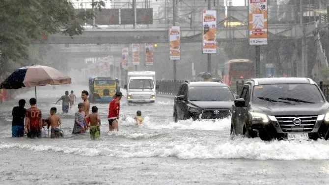
Imagine leaving home on a sunny morning, only to find yourself stuck in traffic a few hours later because the streets have become flooded after a short period of heavy rain. In some parts of Metro Manila, even rainfall lasting less than an hour can disrupt transportation, affect businesses, and make roads difficult or impossible to pass.
This raises an important question: Why does Metro Manila flood so quickly, even when it does not rain for very long?
At first glance, it may seem that flooding should only happen after hours of continuous rainfall. However, urban flooding does not depend on rainfall duration alone. It also depends on how much rain falls within a given period, how quickly water runs off surfaces, how much water drainage systems can carry, and whether the receiving rivers and waterways have enough capacity to accommodate the additional flow.
Metro Manila faces a combination of these challenges. Extensive paved surfaces, drainage limitations, waterways affected by sediment and waste, low-lying areas, and rapid urban development can make certain communities particularly vulnerable to flooding.
To understand why this happens, we need to look at the engineering behind the problem.
Heavy Rainfall Can Produce a Large Volume of Water in a Short Time
One of the first things to understand is that rainfall duration and rainfall intensity are different.
A rainfall event lasting one hour can produce a significant amount of water if the rain is intense. In hydrology, rainfall intensity refers to the amount of precipitation that falls over a particular period, commonly expressed in millimeters per hour.
For example, if an area receives 50 millimeters of rain in one hour, that means approximately 50 liters of water have fallen on every square meter of horizontal surface.
Consider a one-hectare area:
1 hectare = 10,000 square meters
Rainfall = 50 millimeters = 0.05 meters
Total rainfall volume = 10,000 × 0.05
That produces approximately 500 cubic meters of rainwater in just one hour, equivalent to 500,000 liters.
Now imagine that rainfall falling across several hectares of densely developed urban land. The amount of water that needs to be absorbed, stored, or transported through drainage systems becomes substantial.
This is why a short but intense downpour can create serious flooding, especially when the drainage network cannot carry away the incoming water quickly enough.
Concrete Surfaces Prevent Rainwater from Naturally Soaking into the Ground
Another major reason urban areas flood quickly is the amount of land covered by concrete, asphalt, and other impermeable materials.
In a natural environment, rainwater can infiltrate the soil, be absorbed by vegetation, or move gradually through the ground. But in highly developed areas, much of the land is occupied by roads, sidewalks, parking areas, rooftops, and buildings.
These surfaces limit natural infiltration. Instead of entering the ground, a larger portion of rainfall becomes surface runoff, water that flows over the land toward streets, canals, drainage systems, and waterways.
This creates a problem during intense rainfall. Large volumes of runoff can reach drainage systems within a short period, increasing the amount of water that these systems must carry.
In hydrology, this is important because urban development can change both the volume and timing of runoff. Water that would naturally infiltrate or move slowly through vegetated land may reach drainage channels much faster in a densely paved environment.
This does not mean that concrete alone causes Metro Manila's flooding. However, the extensive use of impermeable surfaces makes effective drainage and stormwater management even more important.
Drainage Systems Can Become Overwhelmed
Drainage systems are designed to collect and transport rainwater away from roads and developed areas. They consist of interconnected components such as street inlets, catch basins, underground pipes, canals, drainage channels, and outfalls.
However, these systems have limits.
Every drainage network has a design capacity based on factors such as the expected rainfall, size of the drainage area, pipe dimensions, slope, and downstream conditions.
When the volume of runoff entering the system exceeds its capacity, water begins to accumulate on the surface.
For example, imagine a drainage channel designed to carry a certain amount of water per second. If rainfall produces runoff faster than the channel can discharge it, the excess water has nowhere to go immediately.
This can result in:
Water accumulates along roads and intersections.
Drainage inlets becoming submerged.
Water overflowing from canals and drainage channels.
Floodwater remains on streets even after rainfall stops.
The problem becomes more complicated when drainage networks are old, inadequately maintained, undersized for current conditions, or not properly connected to downstream waterways.
A 2017 research paper, Street Floods in Metro Manila and Possible Solutions, found that many flood-prone locations were situated near intersections of streets and creeks in low-lying areas. The researchers explained that flooding can occur when creeks overflow or when accumulated street water cannot drain quickly enough into nearby streams.
This demonstrates that flooding is not simply a matter of having drainage canals. The entire drainage network must function effectively, from the collection point to the final discharge location.
Clogged Drainage Channels and Waterways Restrict Water Flow
Even when drainage infrastructure is available, its effectiveness can be reduced by obstructions.
Solid waste, sediment, vegetation, and other accumulated materials can restrict water movement through drainage channels and waterways. When this happens, the amount of water that can pass through a particular section may decrease.
This is particularly important in Metro Manila because its flood management system depends not only on drainage canals but also on rivers, creeks, waterways, and pumping stations.
The World Bank has identified solid waste accumulation in waterways and pumping stations as a significant challenge to Metro Manila's flood management. Its discussion of the Metro Manila Flood Management Project also highlighted the need to improve pumping facilities, drainage infrastructure, and solid waste management together.
Why does this matter?
Consider a drainage channel that is supposed to transport rainwater toward a pumping station. If its entrance is obstructed by garbage or sediment, water may not reach the station efficiently. Even if the pumping equipment is operational, the restricted flow can affect the overall drainage process.
This is why regular desilting, clearing of waterways, waste collection, and maintenance of drainage facilities are essential parts of flood management.
Some Areas Are Naturally More Vulnerable Because of Their Elevation
Not all locations in Metro Manila experience flooding in the same way.
Some communities are situated in low-lying areas, near creeks, beside rivers, or in locations where surrounding terrain naturally directs water toward them.
These areas can become collection points for runoff from higher elevations.
A 2017 study using LiDAR-derived elevation data and flood simulations identified many flood-prone street locations around intersections of creeks and roads situated in topographic lows.
In simple terms, water naturally moves toward lower elevations. If a road or community sits in a depression and does not have an adequate drainage outlet, rainwater can accumulate there even when the rainfall is relatively short.
This explains why two neighboring communities may experience different flooding conditions during the same rainfall event.
One area may drain relatively quickly because it has a suitable elevation and functioning drainage connections, while another may experience prolonged flooding because water naturally collects there.
For engineers, understanding the topography of a drainage area is therefore essential before designing flood mitigation measures.
Pumping Stations and High Tide Can Affect How Quickly Floodwater Disappears
Metro Manila relies on pumping stations in several flood-prone areas to help remove accumulated water.
These facilities collect floodwater from drainage networks and discharge it into receiving waterways such as rivers, Manila Bay, or Laguna de Bay.
However, gravity alone cannot always move water out of low-lying areas.
When the water level in the receiving body is higher than the water level inside the drainage system, gravity drainage may become limited. Floodgates may need to close to prevent water from flowing backward into the drainage network. Pumping stations then become particularly important in moving water out.
A University of the Philippines publication discussing Metro Manila's flood control and drainage system explains how pumping stations and floodgates work together when high water levels in Manila Bay prevent water from draining by gravity.
This means that even after rainfall stops, floodwater may not disappear immediately.
Its recession depends on several factors, including the amount of accumulated water, pumping capacity, equipment condition, drainage connections, and the water level of the receiving body.
The World Bank has also emphasized the need to modernize existing pumping stations and construct additional facilities as part of Metro Manila's flood management efforts.
Rapid Urban Development Increases the Challenge
Metro Manila has experienced extensive urban development over the years. Residential buildings, commercial establishments, roads, and other infrastructure have transformed much of its landscape.
While development supports economic activity and provides essential services, it also changes how rainwater moves through an area.
When natural surfaces are replaced by buildings and pavement, stormwater runoff can increase. At the same time, drainage systems designed for older land-use conditions may need improvements to accommodate changing runoff patterns.
Urban development also creates challenges involving land availability, maintenance access, and the preservation of natural waterways.
The World Bank's discussion of Metro Manila flood management identifies rapid urban growth, drainage limitations, encroachment along waterways, and solid waste accumulation as interconnected challenges.
This is why flood management should not be treated as an isolated construction project. It must be considered alongside land-use planning, urban development, environmental management, and infrastructure maintenance.
How Can Engineering Help Reduce Flooding in Metro Manila?
If flooding can happen within an hour, does that mean the solution is simply to build bigger drainage canals? Not necessarily.
Increasing drainage capacity may help in some locations, but flood management requires a coordinated approach. Engineers must understand where the water comes from, how it moves, where it accumulates, and where it can safely be discharged.
Some engineering solutions include:
A. Improving drainage systems
Existing drainage networks can be assessed, repaired, upgraded, or redesigned to accommodate runoff more effectively. This includes evaluating pipe dimensions, channel capacity, drainage connections, and discharge points.
B. Modernizing pumping stations
Pumping stations need reliable equipment, sufficient capacity, regular maintenance, and effective monitoring systems. Their performance is especially important in low-lying locations where gravity drainage is limited.
C. Restoring and maintaining waterways
Regular desilting, clearing obstructions, improving waste collection, and protecting drainage easements can help maintain the flow of water through rivers, creeks, and canals.
D. Introducing green infrastructure
Rain gardens, permeable pavements, green roofs, detention ponds, and urban wetlands can help capture, absorb, or temporarily store stormwater before it enters conventional drainage systems.
E. Improving urban planning
Flood risk assessments, elevation surveys, hydrological studies, and proper land-use planning should be considered before developing areas that naturally collect or convey stormwater.
These approaches are consistent with the direction of the Metro Manila Sponge City Project, which was launched through a partnership involving the Metropolitan Manila Development Authority (MMDA) and the Asian Infrastructure Investment Bank (AIIB) in March 2026.
The project explores combining conventional drainage infrastructure with nature-based solutions such as parks, wetlands, and rivers to capture, slow down, and properly channel rainwater.
The important point is that no single solution can eliminate all flooding. Effective flood management requires infrastructure, environmental measures, maintenance, and coordination among government agencies and communities.
Conclusion: Flooding Is Not Just About How Long It Rains
Metro Manila can experience flooding after a short period of heavy rainfall because urban flooding depends on more than rainfall duration.
The intensity of rainfall, extensive paved surfaces, drainage capacity, clogged waterways, natural elevation, and pumping station performance all influence how quickly water accumulates and how long it takes to disappear.
A one-hour downpour can produce hundreds of thousands of liters of rainwater over a relatively small urban area. When that water cannot infiltrate the ground or move efficiently through drainage systems, flooding becomes a serious problem.
This is why solving urban flooding requires more than simply constructing additional flood-control structures. It requires understanding the entire movement of water, from the moment rain reaches the ground until it eventually reaches rivers, lakes, or the sea.
For civil engineers, this challenge involves hydrology, hydraulics, geotechnical engineering, environmental engineering, and urban planning working together.
Because when it comes to flooding, the real question is not just how much rain falls or how long it lasts. It is whether our cities are designed to handle the water.
References
Lagmay, A. M. F., et al. (2017). Street floods in Metro Manila and possible solutions. Journal of Environmental Sciences. https://pubmed.ncbi.nlm.nih.gov/28888237/
World Bank. (2018). Managing floods for inclusive and resilient development in Metro Manila. https://blogs.worldbank.org/en/water/managing-floods-inclusive-and-resilient-development-metro-manila
World Bank. (2017). Metro Manila Flood Management Project: Environmental and Social Impact Assessment. https://documents1.worldbank.org/curated/en/932441468285638424/pdf/SFG1779-V1-REVISED-EA-P153814-Box402913B-PUBLIC-Disclosed-6-7-2017.pdf
Philippine Atmospheric, Geophysical and Astronomical Services Administration (PAGASA). Weather Terminologies. https://www.pagasa.dost.gov.ph/information/weather-terminologies
Guzman, J. (2026, March 10). MMDA, AIIB meet for 'Sponge City' project vs. NCR flooding. Philippine Information Agency. https://pia.gov.ph/news/mmda-aiib-meet-for-sponge-city-project-vs-ncr-flooding/
University of the Philippines Center for Integrative and Development Studies. Flood Control & Drainage in Metro Manila. https://cids.up.edu.ph/wp-content/uploads/2024/03/Pressures-of-urbanization-flood-control-and-drainage-in-Metro-Manila.pdf
How was the read?
Let us know what you think.
Loading reactions…